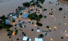
Eastern Africa has experienced heavy rain in recent weeks, with flooding in Kenya, Tanzania and Burundi. About 100,000 people have been displaced or otherwise affected in each country, with 32 reported deaths in Kenya and 58 in Tanzania, alongside damage to farmland and infrastructure.
There are also fears that large areas of standing water could give rise to outbreaks of waterborne diseases.
The Kenyan capital, Nairobi, has been particularly affected this week. The city usually records about 150mm of rain in April, but has so far had an estimated 200-300mm, with some unofficial weather stations having reported much higher amounts. Flooding spread through the city on Wednesday, with people forced to take refuge on their roofs, where many slept overnight.
The increased rainfall is linked to the Indian Ocean Dipole (IOD), a periodic fluctuation in temperature across the Indian Ocean, similar to the better-known El Niño phenomenon in the Pacific. The IOD is now in a positive phase, during which warmer waters move into western parts of the ocean, accentuating rainfall in eastern Africa.
This effect is further intensified when a positive IOD phase coincides with El Niño, as is now the case; a powerful El Niño event that began last June is drawing to a conclusion.
Meanwhile, in Europe, after a very warm start to April, in the past week temperatures fall well below normal for all but Iberia and the eastern Mediterranean. In Munich, temperatures peaked at 25C on 14 April, but fell to 3.6C by 23 April. Overnight frosts were fairly widespread across central Europe and the Balkan peninsula between 20 and 25 April, while parts of France, Germany and the Netherlands experienced locally severe frosts with minimum temperatures as low as -6C.
The unseasonable temperatures resulted from a large area of high pressure that developed towards the north-west and later the west of Europe, allowing colder air to sink southwards across much of the continent. Cooler conditions in late April are not uncommon, but severe frosts in late spring are rare, and can have significant effects on the agricultural industry. Several mitigation measures have been put in place in recent days to protect vulnerable early season plants from frost damage.
after newsletter promotion
Temperatures in central Europe will recover next week, with the warmest spots in Germany and Poland expecting close to 30C by Tuesday, but it will remain cool in Spain and southern France.

